| |
Ground water
Ground
water is one of the major sources for water supply in many parts of
the country. In Delhi too ground water contributes to substantial
quantity of supply. Especially in new development areas ground water
is largely being utilised as a drinking water resource, mainly because
of the insufficiency of the Yamuna water share for Delhi. Ground water
collects in the aquifers over thousands of years through infiltration
and ground water flow recharge. A particular amount of ground water
is replenished regularly through rainwater infiltration. Sustainable
use of ground water means withdrawal of ground water at a rate at
which it is replenished through recharge. Faster withdrawal rates
would lead to fall in water table and finally depletion of ground
water.
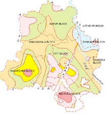
The ground water recharge areas need to be identified so that maximum
recharge can be achieved. The recharge areas needs to conserved and
preserved for the sustainable management of ground water and to maintain
the potential of the ground water in Delhi. According to the Central
ground water board the recharge areas identified is the northernmost
part of the city. Areas where the ponds already exist in the villages,
the Najafgarh jheel and its surroundings and dhe region between the
northern ridge can also be used as water recharge area.
|
CLICK
TO ENLARGE
|
 |
|
CLICK
TO ENLARGE
|
 |
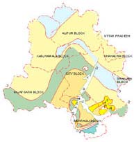
A comparison of water levels from 1962 to 1977,
1977 to 1983 and 1983 to 1995 brings out a clear picture of water
level declines in major parts of the territory.The water levels and
fluctuations during these periods are given in drawing. During 1977,
the water table was by and large within 6m below ground level(bgl)
in major parts of the territory deepest being 23m bgl at near Quatab
minar in Mehrauli Block. In 1983 the depth to water level declined
to 10 m bgl in major parts with the deepest level being 26m bgl at
Mehrauli in Mehrauli Block. In 1995 the extent of area with water
levels in the range of 10 to 20 m bgl has substantially increased
and the deepest water level is about 35 m bgl at Gadaipur in Chattarpur
basin of Mehrauli block.
CLICK
TO ENLARGE
|
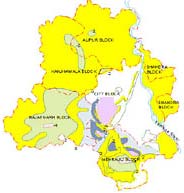
During 1962 1977, the water levels have declined by 2m or
less in most parts of Delhi, rise being confined to northern parts
of Mehrauli block and south western parts of City block. In the Central
Najafgarh block and south eastern part of Chattarpur basin in Mehrauli
block, a fall of 2m to 6m is observed. This is mainly due to intensive
ground water development for irrigation. During 1977- 1983, water
table declined by 4m or less in most parts of Delhi and rise being
confined to small areas in northern Delhi and in the southern part
of Chattarpur basin.
CLICK
TO ENLARGE
Parts of City block ( south-western) and Mehrauli block exhibited
a fall of 4m to 8m during this period due to increased pumpage for
domestic purposes in residential areas and farm houses. During 1983
1995, water levels have declined all over Delhi excepting a small
area in northeast.
Though in most parts of Delhi, the water table decline has been
less than 4m, significantly greater declines ( 4m to more than 8m)
have been recorded in areas in central Najafgarh block, both sides
of the ridges in southern city block and in the Chattarpur basin of
Mehrauli block. Enhanced pumpage for domestic purposes in residential
areas and farm houses has resulted in this significantly greater declines
during this period.
CLICK TO ENLARGE
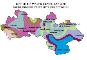
South Delhi
South district has an areal extent of 250 sq km and has population
of 22.58 lakhs ( as per the census, 2001 ). The district is occupied
by diversified geological formations consisting of unconsolidated
Newer and Older alluvium and Quartzites of Delhi Super Group. Quartzite
rocks which occupy the maximum part of south district, have limited
source of availability ground water confining largely to fracture
planes and the weathered zone/mantle. Yield potential of the fracture
zones varies from 100 to 200 lpm. The older alluvium in the Chattarpur
basin consists of predominantly sand with subordinate silt, clay and
kankar. Thickness of alluvium is highly variable because of presence
of sub surface ridges and faults in the district. Except along the
river Yamuna, Ground water level in the district is declining with
rates varying between 1 to 4m per annum. In few pockets in the district,
the rate of decline has been recorded to be 3 to 4m per annum, which
is very alarming.
The reasons for decline in ground water levels are
-
Rapid pace of urbanisation, leading to reduction in recharge of
aquifers.
- Increasing demand in agriculture and industrial sectors
as well as domestic needs for the ever growing population.
- A change in cropping patters in order to raise cash crops
in certain areas.
- Stress laid on ground water extraction during drought
periods when all other sources shrink.
- Unplanned withdrawal from subsoil aquifer.
|
|