|
|
 |
|
|
| |
|
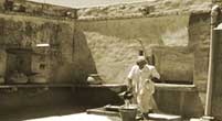
Tankas
Tankas (small tank) are underground tanks, found traditionally
in most Bikaner houses. They are built in the main house or in the
courtyard. They were circular holes made in the ground, lined with
fine polished lime, in which raiwater was collected. Tankas
were often beautifully decorated with tiles, which helped to keep
the water cool. The water was used only for drinking. If in any year
there was less than normal rainfall and the tankas did not
get filled, water from nearby wells and tanks would be obtained to
fill the household tankas. In this way, the people of Bikaner
were able to meet their water requirements. The tanka system
is also to be found in the pilgrim town of Dwarka where it has been
in existence for centuries. It continues to be used in residential
areas, temples, dharamshalas and hotels.
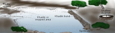
Khadin
A khadin, also called a dhora, is an ingenious construction
designed to harvest surface runoff water for agriculture. Its main
feature is a very long (100-300 m) earthen embankment built across
the lower hill slopes lying below gravelly uplands. Sluices and spillways
allow excess water to drain off. The khadin system is based
on the principle of harvesting rainwater on farmland and subsequent
use of this water-saturated land for crop production.
First designed by the Paliwal Brahmins of Jaisalmer, western Rajasthan
in the 15th century, this system has great similarity with the irrigation
methods of the people of Ur (present Iraq) around 4500 BC and later
of the Nabateans in the Middle East. A similar system is also reported
to have been practised 4,000 years ago in the Negev desert, and in
southwestern Colorado 500 years ago.
Vav / vavdi / Baoli / Bavadi
Traditional stepwells are called vav or vavadi in Gujarat,
or baolis or bavadis in Rajasthan and northern India.
Built by the nobility usually for strategic and/or philanthropical
reasons, they were secular structures from which everyone could draw
water. Most of them are defunct today.
The construction of stepwells date from four periods: Pre-Solanki
period (8th to 11th century CE); Solanki period (11th to 12th century
CE); Vaghela period (mid-13th to end-14th century CE); and the Sultanate
period (mid-13th to end-15th century CE).
Sculptures and inscriptions in stepwells demonstrate their importance
to the traditional social and cultural lives of people.
Stepwell locations often suggested the way in which they would be
used. When a stepwell was located within or at the edge of a village,
it was mainly used for utilitarian purposes and as a cool place for
social gatherings. When stepwells were located outside the village,
on trade routes, they were often frequented as resting places. Many
important stepwells are located on the major military and trade routes
from Patan in the north to the sea coast of Saurashtra. When stepwells
were used exclusively for irrigation, a sluice was constructed at
the rim to receive the lifted water and lead it to a trough or pond,
from where it ran through a drainage system and was channelled into
the fields.
A major reason for the breakdown of this traditional system is the
pressure of centralisation and agricultural intensification.
Ahar
Pynes
This traditional floodwater harvesting system is indigenous to south
Bihar.
In south Bihar, the terrain has a marked slope -- 1 m per km -- from
south to north. The soil here is sandy and does not retain water.
Groundwater levels are low. Rivers in this region swell only during
the monsoon, but the water is swiftly carried away or percolates down
into the sand. All these factors make floodwater harvesting the best
option here, to which this system is admirably suited.
An ahar is a catchment basin embanked on three sides, the 'fourth'
side being the natural gradient of the land itself. Ahar beds were
also used to grow a rabi (winter) crop after draining out the
excess water that remained after kharif (summer) cultivation.
Pynes are articifial channels constructed to utilise river
water in agricultural fields. Starting out from the river, pynes
meander through fields to end up in an ahar. Most pynes flow
within 10 km of a river and their length is not more than 20 km.
The ahar-pyne system received a death-blow under the nineteenth-century
British colonial regime. The post-independent state was hardly better.
In 1949, a Flood Advisory Committee investigating continuous floods
in Bihar's Gaya district came to the conclusion that "the fundamental
reason for recurrence of floods was the destruction of the old irrigational
system in the district." |
|
|
| |
|
Of late, though, some villages in Bihar have taken up the initiative
to re-build and re-use the system. One such village is Dihra.
It is a small village 28 km southwest of Patna city. In 1995, some
village youths realised that they could impound the waters of the
Pachuhuan (a seasonal stream passing through the village that falls
into the nearby river Punpun) and use its bed as a reservoir to meet
the village's irrigation needs. Essentially, this meant creating an
ahar-pyne system
After many doubts, the village powers-that-be gave the go-ahead. Money
was collected and work began in May 1995. After a month of shramdaan
(voluntary labour) the villagers completed their work mid-June.
Their efforts have borne fruit. By 2000 AD, the ahar was irrigating
80 ha of land. The people grow two cereal crops and one crop of vegetables
every year. The returns from the sale of what they produce are good.
The village is no longer a poor one. |
|
|
|
|
| |
|
Bengal's
Inundation Channel
Bengal once had an extraordinary system of inundation canals.
Sir William Willcocks, a British irrigation expert who had also worked
in Egypt and Iraq, claimed that inundation canals were in vogue in
the region till about two centuries ago. Floodwater entered the fields
through the inundation canals, carrying not only rich silt but also
fish, which swam through these canals into the lakes and tanks to
feed on the larva of mosquitoes. This helped to check malaria in this
region. According to Willcocks, the ancient system of overflow irrigation
had lasted for thousands of years. Unfortunately, during the Afghan-Maratha
war in the 18th century and the subsequent British conquest of India,
this irrigation system was neglected, and was never revived.
According to Willcocks, the distinguishing features of the irrigation
system were:
1.) the canals were broad and shallow, carrying the crest waters of
the river floods, rich in fine clay and free from coarse sand;
2.) the canals were long and continuous and fairly parallel to each
other, and at the right distance from each other for purposes of irrigation;
3.) irrigation was performed by cuts in the banks of the canals, which
were closed when the flood was over.
|
|
|
|
|
| |
|
Dungs
or Jampois
Dungs or Jampois are small irrigation channels linking rice fields
to streams in the Jalpaiguri district of West Bengal.
|
|
|
|
|
| |
|
Cheruvu
Cheruvu are found in Chitoor and Cuddapah districts in Andhra
Pradesh. They are reservoirs to store runoff. Cheruvu embankments
are fitted with thoomu (sluices), alugu or marva
or kalju (flood weir) and kalava (canal). |
|
|
|
|
| |
|
Kohli
Tanks
The Kohlis, a small group of cultivators, built some 43,381 water
tanks in the district of Bhandara, Maharashtra, some 250-300 years
ago. These tanks constituted the backbone of irrigation in the area
until the government took them over in the 1950s. It is still crucial
for sugar and rice irrigation. The tanks were of all sizes, often
with provisions to bring water literally to the doorstep of villagers.
|
|
|
|
|
| |
|
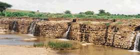
Bhanadaras
These are check dams or diversion weirs built across rivers. A traditional
system found in Maharashtra, their presence raises the water level
of the rivers so that it begins to flow into channels. They are also
used to impound water and form a large reservoir.
Where a bandhara was built across a small stream, the water
supply would usually last for a few months after the rains.
They are built either by villagers or by private persons who received
rent-free land in return for their public act
Most Bandharas are defunct today. A very few are still in use. |
|
|
|
|
| |
|
Phad
The community-managed phad irrigation system, prevalent in northwestern
Maharashtra, probably came into existence some 300-400 years ago.
The system operated on three rivers in the Tapi basin - Panjhra, Mosam
and Aram - in Dhule and Nasik districts (still in use in some places
here).
|
|
|
|
|
The system starts with a bandhara (check dam or diversion-weir)
built across a rivers. From the bandharas branch out kalvas
(canals) to carry water into the fields. The length of these canals
varies from 2-12 km. Each canal has a uniform discharge capacity of
about 450 litres/second. Charis (distributaries) are built
for feeding water from the kalva to different areas of the phad.
Sarangs (field channels) carry water to individual fields.
Sandams (escapes), along with kalvas and charis,
drain away excess water. In this way water reaches the kayam baghayat
(agricultural command area), usually divided into four phads
(blocks).
The size of a phad can vary from 10-200 ha, the average being
100-125 ha. Every year, the village decides which phads to use and
which to leave fallow. Only one type of crop is allowed in one phad.
Generally, sugarcane is grown in one or two phads; seasonal crops
are grown in the others. This ensures a healthy crop rotation system
that maintains soil fertility, and reduces the danger of waterlogging
and salinity.
The phad system has given rise to a unique social system
to manage water use.
|
|
|
| |
|
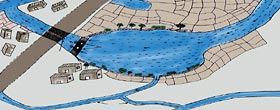
Kere
Tanks, called kere in Kannada, were the predominant traditional method
of irrigation in the Central Karnataka Plateau, and were fed either
by channels branching off from anicuts (chech dams) built across
streams, or by streams in valleys. The outflow of one tank supplied
the next all the way down the course of the stream; the tanks were
built in a series, usually situated a few kilometres apart. This ensured
a) no wastage through overflow, and b) the seepage of a tank higher
up in the series would be collected in the next lower one. |
|
|
|
|
|
|
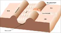
The
Ramtek model has been named after water harvesting structures in
the town of Ramtek, Maharashtra. A scientific analysis revealed an
intricate network of groundwater and surface waterbodies, intrinsically
connected through surface and underground canals. A fully evolved
system, this model harvested runoff through tanks, supported by high
yielding wells and structures like baories,
kundis, and waterholes.
This system, intelligently designed to utlise every raindrop falling
in the watershed area is disintegrating due to neglect and ignorance.
Constructed and maintained mostly by malguzars (landowners),
these tanks form a chain, extending from the foothills to the plains,
conserving about 60-70 per cent of the total runoff. Once tanks located
in the upper reaches close to the hills were filled to capacity, the
water flowed down to fill successive tanks, generally through interconnecting
channels. This sequential arrangement generally ended in a small waterhole
to store whatever water remained unstored.
The presence of the Ramtek ridge in the middle, having a steep slope
on both sides, results in quick runoffs and little percolation. This
might have led the residents of the southern plains of the Ramtek
hills to construct different types of water conservation structures
(like tanks) where they could trap the maximum |
|
|
|
|
| |
|
Zings
Zings are water harvesting structures found in Ladakh. They are
small tanks, in which collects melted glacier water.
|
|
|
Essential to the system
is the network of guiding channels that brings the water from the
glacier to the tank. As glaciers melt during the day, the channels
fill up with a trickle that in the afternoon turns into flowing water.
The water collects towards the evening, and is used the next day.
A water official called the churpun ensures that water is equitably
distributed. |
|
|
|