|
|
 |
|
|
| |
|
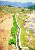
Kul
Kuls are water channels found in precipitous mountain areas. These
channels carry water from glaciers to villages in the Spiti valley
of Himachal Pradesh. Where the terrain is muddy, the kul is
lined with rocks to keep it from becoming clogged. In the Jammu region
too, similar irrigation systems called kuhls are found.
Naula
Naula is a surface-water harvesting method typical to the hill areas
of Uttaranchal. These are small wells or ponds in which water is collected
by making a stone wall across a stream.
Khatri
Khatris are structures, about 10x12 feet in size and six feet
deep carved out in the hard rock mountain. The specially trained masons
construct them at a cost of Rs 10,000-20,000 each. These traditional
water harvesting structures are found in Hamirpur, Kangra and Mandi
districts of Himachal Pradesh.
There are two types of khatris: one for animals and washing purposes
in which rain water is collected from the roof through pipes, and
other used for human consumption in which rainwater is collected
by seepage through rocks. Interestingly, the khatris are owned by
individual as well as by a community. There are government khatris
as well, which are maintained by the panchayat.
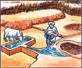
Kuhl
Kuhls are a traditional irrigation system in Himachal Pradesh-
surface channels diverting water from natural flowing streams (khuds).
A typical community kuhl services six to 30 farmers, irrigating
an area of about 20 ha. The system consists of a temporary headwall
(constructed usually with river boulders) across a khud (ravine)
for storage and diversion of the flow through a canal to the fields.
By modern standards, building kuhls was simple, with boulders
and labour forming the major input. The kuhl was provided with
moghas (kuchcha outlets) to draw out water and irrigate
nearby terraced fields. The water would flow from field to field and
surplus water, if and, would drain back to the khud.
The kuhls were constructed and maintained by the village community.
At the beginning of the irrigation season, the kohli (the water tender)
would organise the irrigators to construct the headwall, repair the
kuhl and make the system operational. The kohli played the role of
a local engineer. Any person refusing to participate in construction
and repair activities without valid reason, would be denied water
for that season. Since denial of water was a religious punishment,
it ensured community participation and solidarity. A person was also
free to participate by providing a substitute for his labour. The
kohli also distributed and managed the water.
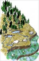
Zabo
The zabo (the word means 'impounding run-off') system is practiced
in Nagaland in north-eastern India. Also known as the ruza
system, it combines water conservation with forestry, agriculture
and animal care.
Villages such as Kikruma, where zabos are found even today, are located
on a high ridge. Though drinking water is a major problem, the area
receives high rainfall. The rain falls on a patch of protected forest
on the hilltop; as the water runs off along the slope, it passes through
various terraces. The water is collected in pond-like structures in
the middle terraces; below are cattle yards, and towards the foot
of the hill are paddy fields, where the run-off ultimately meanders
into.
Cheo-ozihi
The river Mezii flows along the Angami village of Kwigema in Nagaland.
The riverwater is brought down by a long channel. From this channel,
many branch channels are taken off, and water is often diverted to
the terraces through bamboo pipes. One of the channels is named Cheo-oziihi
- oziihi means water and Cheo was the person responsible
for the laying of this 8-10 km-long channel with its numerous branches.
This channel irrigates a large number of terraces in Kwigwema, and
some terraces in the neighbouring village. There are three khels
and the village water budget is divided among them.
|
|
|
| |
|
Eri
Approximately one-third of the irrigated area of Tamil Nadu is watered
by eris (tanks). Eris have played several important
roles in maintaining ecological harmony as flood-control systems,
preventing soil erosion and wastage of runoff during periods of heavy
rainfall, and recharging the groundwater in the surrounding areas.
The presence of eris provided an appropriate micro-climate
for the local areas. Without eris, paddy cultivation would
have been impossible.
Till the British arrived, local communities maintained eris.
Historical data from Chengalpattu district, for instance, indicates
that in the 18th century about 4-5 per cent of the gross produce of
each village was allocated to maintain eris and other irrigation
structures. Assignments of revenue-free lands, called manyams,
were made to support village functionaries who undertook to maintain
and manage eris. These allocations ensured eri upkeep
through regular desilting and maintenance of sluices, inlets and irrigation
channels.
The early British rule saw disastrous experiments with the land tenure
system in quest for larger land revenues. The enormous expropriation
of village resources by the state led to the disintegration of the
traditional society, its economy and polity. Allocations for maintenance
of eris could no longer be supported by the village communities,
and these extraordinary water harvesting systems began to decline.
Read more about Ganesan,
the neerkatti who managed eris
|
|
|
|
|
| |
|
Ooranis
The tanks, in south Travancore, though numerous, were in most cases
oornis containing just enough water to cultivate the few acres of
land dependent on them. The irregular topography of the region and
the absence of large open spaces facilitated the construction of only
small tanks unlike large ones seen in the flat districts of the then
Madras Presidency, now Tamil Nadu. |
|
|
|
|
| |
|
Dongs
Dongs are ponds constructed by the Bodo tribes of Assam to harvest
water for irrigation. These ponds are individually owned with no community
involvement. |
|
|
|
|
| |
|
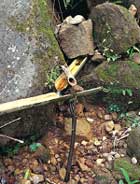
Bamboo
Drip Irrigation
Meghalaya has an ingenious system of tapping of stream and springwater
by using bamboo pipes to irrigate plantations. About 18-20 litres
of water entering the bamboo pipe system per minute gets transported
over several hundred metres and finally gets reduced to 20-80 drops
per minute at the site of the plant. This 200-year-old system is used
by the tribal farmers of Khasi and Jaintia hills to drip-irrigate
their black pepper cultivation.
Bamboo pipes are used to divert perennial springs on the hilltops
to the lower reaches by gravity. The channel sections, made of bamboo,
divert and convey water to the plot site where it is distributed without
leakage into branches, again made and laid out with different forms
of bamboo pipes. Manipulating the intake pipe positions also controls
the flow of water into the lateral pipes. Reduced channel sections
and diversion units are used at the last stage of water application.
The last channel section enables the water to be dropped near the
roots of the plant.
Bamboos of varying diameters are used for laying the channels. About
a third of the outer casing in length and internodes of bamboo pieces
have to be removed while fabricating the system. Later, the bamboo
channel is smoothened by using a dao, a type of local axe, a round
chisel fitted with a long handle. Other components are small pipes
and channels of varying sizes used for diversion and distribution
of water from the main channel. About four to five stages of distribution
are involved from the point of the water diversion to the application
point. |
|
|
|
|
| |
|
Apatani
This is a wet rice cultivation cum fish farming system practiced in
elevated regions of about 1600 m and gentle sloping valleys, having
an average annual rainfall about 1700 mm and also rich water resources
like springs and streams. This system harvests both ground and surface
water for irrigation. It is practiced by Apatani tribes of ziro in
the lower Subansiri district of Arunachal Pradesh.
In Apatani system , valleys are terraced into plots separated by
0.6 meters high earthen dams supported by bamboo frames. All plots
have inlet and outlet on opposite sides. The inlet of lowlying plot
functions as an outlet of the high lying plot. Deeper channels connect
the inlet point to outlet point. The terraced plot can be flooded
or drained off with water by opening and blocking the inlets and
outlets as and when required. The stream water is tapped by constructing
a wall of 2-4 m high and 1 m thick near forested hill slopes. This
is conveyed to agricultural fields through a channel network.
|
|
|
|
|
| |
|
Virdas
Virdas are shallow wells dug in low depressions called jheels
(tanks). They are found all over the Banni grasslands, a part of the
Great Rann of Kutch in Gujarat. They are systems built by the nomadic
Maldharis, who used to roam these grasslands. Now settled, they persist
in using virdas.
These structures harvest rainwater. The topography of the area is
undulating, with depressions on the ground. By studying the flow of
water during the monsoon, the Maldharis identify these depressions
and make their virdas there.
Essentially, the structures use a technology that helps the Maldharis
separate potable freshwater from unpotable salt water. After rainwater
infiltrates the soil, it gets stored at a level above the salty groundwater
because of the difference in their density. A structure is built to
reach down (about 1 m) to this upper layer of accumulated rainwater.
Between these two layers of sweet and saline water, there exists a
zone of brackish water. As freshwater is removed, the brackish water
moves upwards, and accumulates towards the bottom of the virda.
|
|
|
|
|
| |
|
Katas
/ Mundas / Bandhas
The katas, mundas and bandhas were the main irrigation
sources in the ancient tribal kingdom of the Gonds (now in Orissa
and Madhya Pradesh). Most of these katas were built by the village
headmen known as gountias, who in turn, received the land from the
Gond kings. Land here is classified into four groups on the basis
of its topography: aat, (highland); mal (sloped land);
berna (medium land); and bahal (low land). This classification
helps to select
A kata is constructed north to south, or east to west, of a
village. A strong earthen embankment, curved at either end, is built
across a drainage line to hold up an irregularly-shaped sheet of water.
The undulations of the country usually determine its shape as that
of a long isosceles triangle, of which the dam forms the base. It
commands a valley, the bottom of which is the bahal land and
the sides are the mal terrace. As a rule, there is a cut high
up on the slope near one end of the embankment from where water is
led either by a small channel or tal, or from field to field along
terraces, going lower down to the fields. In years of normal rainfall,
irrigation was not needed because of moisture from percolation and,
in that case, the surplus flow was passed into a nullah. In years
of scanty rainfall, the centre of the tank was sometimes cut so that
the lowest land could be irrigated.
|
|
|
|
|
| |
|
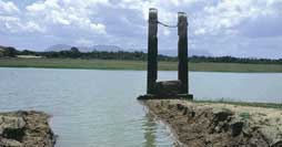
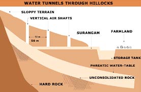
Surangam
Kasaragod district in the northern Malabar region of Kerala is an
area whose people cannot depend directly on surface water. The terrain
is such that there is high discharge in rivers in the monsoon and
low discharge in the dry months. People here depend, therefore on
groundwater, and on a special water harvesting structure called surangam.
The word surangam is derived from a Kannada word for tunnel.
It is also known as thurangam, thorapu, mala, etc, in
different parts of Kasaragod. It is a horizontal well mostly excavated
in hard laterite rock formations. The excavation continues until a
good amount of water is struck. Water seeps out of the hard rock and
flows out of the tunnel. This water is usually collected in an open
pit constructed outside the surangam.
A surangam is about 0.45-0.70 metres (m) wide and about 1.8-2.0
m high. The length varies from 3-300 m. Usually several subsidiary
surangams are excavated inside the main one. If the surangam
is very long, a number of vertical air shafts are provided to ensure
atmospheric pressure inside. The distance between successive air shafts
varies between 50-60 m. The approximate dimensions of the air shafts
are 2 m by 2 m, and the depth varies from place to place.
Surangams are similar to qanats which once existed in Mesopotamia
and Babylon around 700 BC.1,2 By 714 BC, this technology had spread
to Egypt, Persia (now Iran) and India. The initial cost of digging
a surangam (Rs 100-150 per 0.72 m dug) is the only expenditure
needed, as it hardly requires any maintenance. Traditionally, a
surangam was excavated at a very slow pace and was completed over
generations. Today, engineers such as Kunnikannan
Nair are faster and keep the tradition alive.
|
|
|
|
|
| |
|
Korambus
Korambu is a temporary dam stretching across the mouth of channels,
made of brushwood, mud and grass. It is constructed by horizontally
fixing a strong wooden beam touching either banks of the canal. A
series of vertical wooden beams of appropriate height is erected with
their lower ends resting firmly on the ground and the other ends tied
to the horizontal beam. Closely knitted or matted coconut thatch is
tied to this frame. A coat of mud is applied to the matted frame.
A layer of grass is also applied carefully which prevents dissolution
of the applied mud. Korambu is constructed to raise the water level
in the canal and to divert the water into field channels. It is so
built that excess water flows over it and only the required amount
of water flows into the diversion channels. The height of the Korambu
is so adjusted that the fields lying on the upstream are not submerged.
Water is allowed to flow from one field to another until all the field
are irrigated. They are built twice a year especially before the onset
of the monsoon season in order to supply water during winter and summer
season. In Kasargod and Thrissur districts of Kerala, Korambu is known
as chira. |
|
|
|
|
| |
|
Jackwells
The difference in the physiography, topography, rock types and rainfall
meant that the tribes in the different islands followed different
methods of harvesting rain and groundwater. For instance, the southern
part of the Great Nicobar Island near Shastri Nagar has a relatively
rugged topography in comparison to the northern part of the islands.
The shompen tribals here made full use of the topography to harvest
water. In lower parts of the undulating terrain, bunds were made using
logs of hard bullet wood, and water would collect in the pits so formed.
They make extensive use of split bamboos in their water harvesting
systems. A full length of bamboo is cut longitudinally and placed
along a gentle slope with the lower end leading into a shallow pit.
These serve as conduits for rainwater which is collected drop by drop
in pits called Jackwells. Often, these split bamboos are placed under
trees to harvest the throughfalls (of rain) through the leaves. A
series of increasingly bigger jackwells is built, connected by split
bamboos so that overflows from one lead to the other, ultimately leading
to the biggest jackwell, with an approximate diameter of 6 m and depth
of 7 m so that overflows from one lead to the other.
|
|
|
|
|
|